Posts

Showing posts from 2024

Exploring the Origins of Big Sur's Enigmatic Seafloor Pockmarks

Image
Off the coast of Big Sur, California, lies a fascinating underwater landscape marked by large holes in the clay, silt, and sand. These pockmarks, discovered decades ago, have long puzzled scientists. Recent research by the Monterey Bay Aquarium Research Institute (MBARI) and Stanford University has shed new light on their formation. The Sur Pockmark Field, the largest of its kind in North America, spans an area equivalent to Los Angeles and contains over 5,200 hollows, each measuring up to 175 meters wide and 5 meters deep. These pockmarks are found at depths ranging from 500 to 1,500 meters. Unlike typical pockmarks formed by the release of methane or other fluids, the Sur Pockmarks appear to be shaped by gravitational forces. Analysis of sediment samples indicates that sediment has flowed down the continental slope intermittently for at least 280,000 years, with a significant flow occurring 14,000 years ago, likely triggered by an earthquake or slope collapse. This process erodes the

The Ocean's Salty Secret: How Underwater Mixing Shapes Surface Salinity

Image
Ever wondered why the ocean is salty? Unlike a bowl of soup, the ocean doesn't get its saltiness from a giant salt shaker in the sky. The answer lies in a fascinating interplay between land, seafloor, and even volcanoes! There are two main sources of ocean salt: 1. Land Runoff: Rainwater acts like a tiny sculptor, slowly eroding rocks on land. These rocks contain various minerals, including some that dissolve easily in water, forming ions (charged particles). These ions get carried away by rivers and streams and eventually end up in the ocean. While some of these ions are used by ocean life, others accumulate over time, making the ocean saltier. 2. Seafloor Vents and Volcanoes: Deep down on the ocean floor, things get hot! Superheated water seeps through cracks and gets cooked by Earth's molten core. This heat triggers a series of chemical reactions, dissolving metals from surrounding rocks and releasing them into the water, along with other minerals. These "hydrother

Antarctica Sea Ice Mystery? The Truth Behind the Enormous Ice Gap

Image
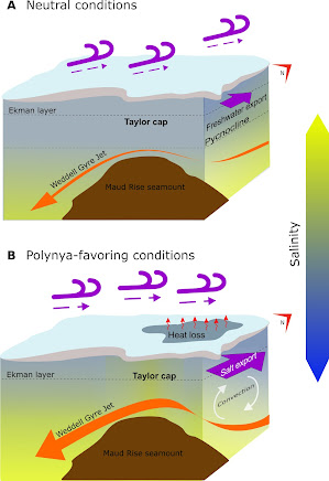
Scientists have discovered evidence for the open-ocean polynya formed over the Maud Rise, in the Wendell Sea, during the winters of 2016-2017. The study reveals the key process on how the polynya was able to form and persist for several weeks. The team of researchers from the University of Southampton, the University of Gothenburg and the University of California San Diego studied the Maud Rise polynya. They found that the polynya was brought on by interactions between the wind, ocean flow and geography resulting in vertical missing of the heat and salt towards the sea surface. Polynyas are openings in the winter sea ice that act like giant vents, exposing the warm water below to the freezing air above. Coastal Polynyas are regular visitors along the Antarctic coast where strong winds push sea ice away from the land, creating open water. Open-Ocean Polynyas are rare events that occur in the middle of the Southern Ocean. They are often linked to changes in the ocean's saltiness, w